How much do you know about Denver streets, avenues, and boulevards?
If you're like most of us, you've only considered the logic of Denver's roadways in passing, usually while driving and randomly thinking, "What is Galapago Street named after?"
Or maybe it's after a passionate argument with a Denver native who insists that Zuni Street is pronounced "zun-eye" and that the Indian tribe is pronounced "zoo-knee?" But if you've ever spent some time with local historian Phil Goodstein's relatively compact, but factually dense, Denver Streets: Names, Numbers, Locations, Logic, you'll walk away with a much better understanding of the quirks and intricacies of Denver streets.
First published in 1994, Denver Streets was conceived as an article for Colorado History, but quickly turned into a full-blown book all its own. Goodstein, who was surprised by the book's commercial success, published a second edition in 1995. He's also the first person to admit that, due to the myriad of quirks, intricacies, and general confusion that defined the development of Denver's roads, Denver Streets is an imperfect volume. That said, the book is incredibly useful for anyone with even a passing interest in how Denver came to be Denver (and it's one of the most used reference resources in Denver Public Library's Western History and Genealogy (WHG) Department).
The Origins of Denver Streets
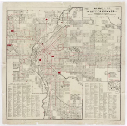
"In part, it was a legacy of my father making up stories about the streets as we rode about the city when I was a boy," is how Goodstein describes the genesis of his book. But once he started researching, it was pretty clear that he'd come across a very deep and challenging subject that would require all of his skills as a researcher. "It was soon obvious that there was a pamphlet on the topic, if not a book. Before long, I was spending afternoons in the city engineer’s office where I examined countless 19th-century maps and plats of neighborhoods."
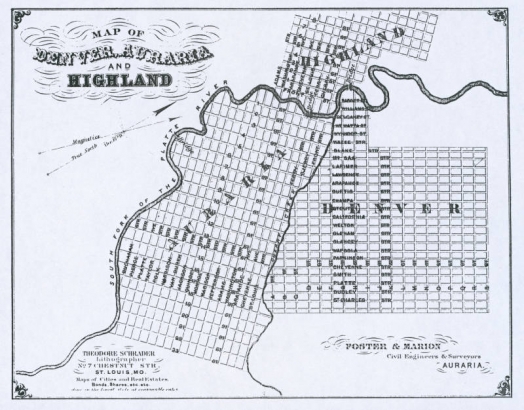
The more Goodstein dug, the more Byzantine Denver's street layouts appeared. Time and time again he'd stumble across multiple spellings of the same street and strange doings that were the result of a "chaotic street system." Part of the confusion of Denver streets was brought on by the fact that what we know as Denver today is actually a conglomeration of defunct municipalities (including Auraria, Highlands, and Welby) that didn't coordinate the layout of their towns.
For example, Auraria's streets were aligned with Cherry Creek, while Denver's streets lined up with the Platte, even though both towns based their layouts on a north/south grid. (It's also worth noting that both bodies of water take very different paths through Denver today than they did in 1859.) But neither Denver nor Auraria's grids conformed to what the federal government wanted from new territories: a more formal east/west style—which is what developers like Henry Brown introduced when they laid out areas such as Capitol Hill.
But not every developer, or mapmaker, was as fastidious as Brown. They created odd-sized lots and blocks, changed street names at will, and generally operated without any consistency whatsoever. "These different street patterns are still most visible. Often where streets jog, one real estate subdivision is ending and another is beginning," Goodstein says. "This is evident along Colfax Avenue where frequently the streets on one side of the boulevard do not directly connect with those on the other side."
Taming Denver's Streets
Denver Streets is teeming with examples of chaos and inconsistency, but beginning in the 1870s, several efforts were made to tame the disorder and deliver something like a coherent grid.
One of the greatest challenges for city planners was corralling Denver's avenues, which were an unintelligle mess. An 1871 plan tried to bring together numbered streets and numbered avenues. (Adding to the confusion was the fact that many numbered avenues had been renamed for prominent people. For example, 17th Avenue was once named Brown Avenue after the developer.)
Goodstein notes:
The new system specified that the avenues would correspond with the numbered streets, i.e., 17th Avenue was defined as the road running east from 17th Street at Broadway.In other words, First Avenue was not arbitrarily chosen as the first avenue in town because it is the first road north of the Denver Country Club as is sometimes thought, rather, the number avenues started with 17th Avenue and counted down block by block for 16 blocks on the east side of Broadway until a first avenue was reached.
In this cacophony of streets and avenues, an actual voice of reason emerged in the form of a Dutch-born mapmaker named Edward Rollandet. Rollandet's work was so authoritative that city officials sometimes codified formal street names based on it. Goodstein cites him as a "premier" source of information about Denver streets and the staff at WHG can attest to the quality of Rollandet's work.
Enter Maloney
As the 19th century drew to a close, Denver was still annexing nearby municipalities. Streets that had once cut through multiple towns often retained their old names, meaning a street could change names multiple times as it headed across town. This was a major problem for the Denver Union Water Company, a private provider of water services. More specifically, the company's bills and installers were not always going to the right address.
To combat this problem, a bookkeeper at the company named Howard Maloney proposed a major overhaul of Denver street names that would, among other things, make certain that continuous streets retained their same name all the way across town. Maloney is also responsible for instituting street name series, such as the Indian tribe series (Arapahoe, Bannock, etc.), and the great Americans series (Wolcott, Hooker, etc.).
City planners liked the idea so much that they codified it into law via Ordinance 19 in 1904.
While Maloney's system introduced true order to a very chaotic system, it was rife with quirks that seem to defy logic, as Goodstein notes in incredible detail. For example, why is Jason Street, which is named for the Jason of antiquity, the "J" street in the Indian series?
Making Sense of It All
The story of Denver's streets takes as many twists and turns as the streets of Denver. But Goodstein has done a phenomenal job of tying the whole story together. Particularly interesting are the sections on "Yesterday's Streets," which methodically trace the voluminous changes Denver street names have taken over the years.
As much as anything, Denver Streets: Names, Numbers, Locations, Logic showcases the incredible contributions that local historians make to the communities they research and write about. This particular title serves historians, land developers, and plenty of regular folks who simply want to learn more about their hometown.


Comments
Hello! Is there any
Hello! Is there any information on where the name for W Walsh Pl came from? The streets around it don't seem to have a name pattern to speak of.
Thank you,
Erin
Hello!
Hello!
I find this topic to be incredibly fascinating. From what I can gather, this book isn't allowed to be borrowed from the library (and the library is currently temporarily closed due to Covid-19). Do you know of any sources where I might be able to purchase a copy?
Hi Nessie - We agree that
Hi Nessie - We agree that this is a wonderfully fascinating subject and Phil's research on it is top notch. Unfortunately, the book appears to be out-of-print and copies are hard to come by, but do pop up on used book sites (usually with a very large mark up. Sorry we don't have better news.
There are a few copies at
There are a few copies at Amazon ---priced from $92-$900 plus . . . one for $114, postage paid. I treasure my copy, signed by Phil on his "Pacing the Streets" walking tour July 14, 1998. Today I'm trying to figure out the current address for 1852 Curtis street, where George William Lechner lived in 1890. I think it is time to look at the "fire" maps. . . and keep hoping for the day the library will be open for research on the 5th floor!
Add new comment