I’ve been reviewing some negatives of Denver street scenes from the 1950s in the Denver Public Works Records (WH1741). This collection of negatives was created by Traffic Engineers with the Public Works department to document innovations—and perhaps problems—with Denver’s traffic flow.
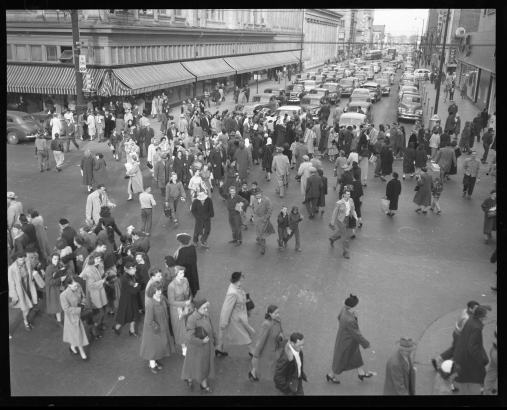
The photographs are fascinating. Photos depicting places that have changed drastically over time are among the most amazing. Anyone familiar with downtown Denver, South Broadway or Tennyson Street today will agree that a lot has changed. The image (above) of 16th and Champa is wonderful because it shows pedestrians nearly taking over the downtown intersection, crossing diagonally (an idea known as the “Barnes Dance,” which was minted in Denver during the 1950s). Some of the children in the center of the photo must have been waving at the photographer perched above, prompting the question - how exactly did they get that vantage point?
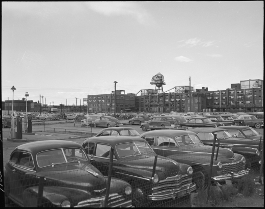
This image of a Gates Corporation parking lot shows the long-familiar Gates sign above the now-demolished rubber company plant at Broadway and Mississippi. But what also stands out is the parking lot full of workers’ cars. Today, RTD light rail can take you close to that spot.
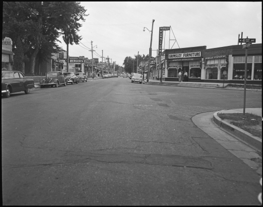
Tennyson Street in North Denver will look strangely familiar to anyone who knows that intersection today. It was, and is, a commercial hub in Denver’s Berkeley neighborhood, and many of the buildings still stand. The photograph above depicts Tennyson as a much quieter street than it is in 2019, and the neighborhood signs show more retail and services than you’ll find there today. Presently the commercial strip is dominated by restaurants and bars.
What stands out to you in these images of 1950s Denver?


Comments
My childhood in Denver.
My childhood in Denver. Beach Ct., Cory, & Bradley Elementary; Merrill Jr Hi; South and TJ High. Going to movies downtown on the bus on Saturday. Valley Highway flooding from rain storms. Radio programs for kids, & no tv until 1952 then one tv station -- Channel 2, antennas on almost every house. Barnes dance -- way ahead of its time. Etc, etc, etc...
Thank you for adding this
Thank you for adding this terrific list of your memories of Denver places during this time frame. Agreed that the Barnes dance must have seemed like an idea ahead of its time!
Hi Abby, I'm with Historic
Hi Abby, I'm with Historic Berkeley Regis, a neighborhood group involved in identifying, researching, and celebrating historic resources in northwest Denver. We have searched the DPL website for images of our area in the past, and I don't recall the one of Tennyson coming up. Is it from a newly acquired collection? Are there others of Tennyson or other Berkeley Regis resources? Great photos and blog post! Thanks, Tom Simmons, frraden@msn.com, 303-477-7597
Thank you for your comment,
Thank you for your comment, Tom. These items have only been recently scanned for the digital collections online, but the collection has been in the library for several years. Come in any time to see the Denver Public Works Records (WH1741) in person. There are a few more negatives from the Berkeley neighborhood in there that haven't yet been scanned.
the Gates parking is
the Gates parking is interesting in several ways; for one thing, the histories i've read suggest that a large portion of Gates employees had lived in the surrounding neighborhoods; either they didn't feel like walking a few blocks, or many of them lived farther away at this point
note the gas pumps; did Gates perhaps provide discount gasoline to its employees? this might induce them to drive even if the distance were short; and when we reviewed the various contamination issues on this part of the property, i don't recall the presence of underground gasoline tanks (which very commonly contaminated surrounding soil) to have been noted
finally, i don't see a single car in the Gates lot that has a curved windshield; some employees might have had older cars, but not every one of them; does this help date the photo?
I'm going to suggest you are
I'm going to suggest you are looking towards the east at the back side of the plant from Santa Fe and Mississippi. On that corner stood an employee service station and there was a tunnel into the plant under the railroad tracks.
Doug, thanks for providing
Doug, thanks for providing this background information on the vantage point from which this photograph was taken.
I'm going to suggest you are
I'm going to suggest you are looking towards the east at the back side of the plant from Santa Fe and Mississippi. On that corner stood an employee service station and there was a tunnel into the plant under the railroad tracks.
Steve, thank you for you
Steve, thank you for you comment. The questions you raise are good examples of the type of inquiry that can emerge from using a photograph as a primary source research tool. Probably dating the makes/models of the cars in the lot would be our best bet to narrow the date range when the photo might have been taken. Thanks for sharing your observations!
The "16th and Curtis" picture
The "16th and Curtis" picture is incorrectly labeled - if you zoom in on the street signs, top right corner it shows the cross sign intersection of 16th and Champa.
Add new comment