Play trivia long enough and you'll get asked to name one or both of the 'square states'; A fun way to annoy the trivia host is to remind them that they are wrong—both Colorado and Wyoming are rectangular. But are they really?
On the drawing board, Colorado started out rectangular. Just before the Civil War, on February 28, 1861, the 36th Congress established the boundaries of the new territory as being between 37 and 41 degrees north of the equator, and 25 and 32 degrees west from Washington, DC. This sweeping measure carved out land from the territories of Kansas in the east, Utah in the west, Nebraska in the north (Dakota Territory wasn’t formed until a few days later) and New Mexico in the south.
At this point, Colorado’s boundary was still perfectly rectangular, but not for much longer. In the 1860s and 1870s, Congress authorized official surveys to establish boundary markers and funny things began to happen. Long before GPS helped us find our way around, surveyors had to use more error-prone tools. Or, more accurately, the tools were used by error-prone humans. This led to lots of zigs and zags in surveying lines.
Pressed for time, these zigzags were usually followed by steep corrections up to a mile or more back to the proper line rather than having the team go back and re-survey a given stretch.
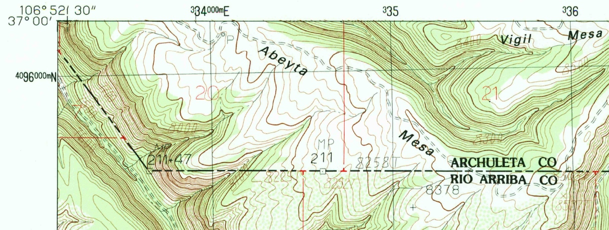
In the most famous example along Colorado’s boundary, the Four Corners area was marked about 1,800 feet east of where it should have been placed. However, under U.S. law, once the parties (in this case the states and territories) agreed on the marker’s placement it became the actual boundary. This also holds true for all of the numerous zigs and zags that make up our border. And while state maps still show the boundary as straight, any detailed topographic map (we have almost all of them in the Western History and Genealogy Department) offers a glimpse into the lives of those surveyors from the late 19th century as they laid out our modern boundaries.
Further Reading:
Geological Survey (U.S.). 1:24,000-scale topographic map of Monero, NM-CO (1983). Image at the top of this post taken from this map. USGS's Topo Viewer is the best place to find historic USGS topographic maps online.
Van Zandt, F.K. Boundaries of the United States and the several States. Professional Paper 909 (1976). Good summary of all the state boundaries.
Everett, Derek R. Creating the American West: boundaries and borderlands (2014). Up-to-date take on the western borders of the U.S.
Statutes at Large, 36th Congress, 2nd Session (page 172). 12 Stat. L. p.172 (ch.59). February 28, 1861. Established boundary of Colorado as being between 37th and 41st parallel (latitude) and 25th and 32nd meridian (longitude, west from Washington DC)
Comments
So what you're saying is that
So what you're saying is that I can no longer bake a sheet cake and correctly say it's the shape of Colorado? Maybe I should take little bites out of the edges, to more accurately represent the topographical lines? I could get on board with this!
Thanks for that great
Thanks for that great suggestion! In many cases the line extends well into New Mexico for long stretches. The end of one of those stretches can be seen in the map at the top of this post. So the best option is to make a bigger cake. Everyone wins!
Great info Craig!! I
Great info Craig!! I remember hearing something so I looked at Google maps really really close up and noticed a bit of zigging and zagging! I had no idea why or how it happened though. Thanks!
Thank you for your comment!
Thank you for your comment! Yep, Google and MapQuest both show it since the datasets they use are fairly standard in the geospatial world.
Thanks for your comment Jeff!
Thanks for your comment Jeff! I think it's safe to say that most people will always consider Colorado a square state -- at least regarding its borders.
On some map projections
On some map projections Colorado is a rectangle. On others it resembles a trapezoid with its shorter northern and longer southern state lines having a slight curve. On a globe, and in reality, all of Colorado's borders are curved. It's far from square ☺
Right, and thanks for the
Right, and thanks for the comment! Map projections can make any area look different. The word 'square' here comes from the popularly used term for the shape of the state -- and definitely not from a more pure geometrical perspective. Most likely the term originated from a time when the Mercator projection was still used on many school maps. That projection was great at its original purpose of ship navigation in the early modern era, but more than a little misleading when people started applying it to educational wall maps.
Colorado has nearly 700 sides
Colorado has nearly 700 sides! This is true.I've seen a video and i heard that Craig.
I'm not surprised. All in all
I'm not surprised. All in all, they were surprisingly accurate considering the limited tools they had at their disposal, and the rough terrain. Thanks for your comment!
Did you know something?
Did you know something? Although Colorado has only a few parts that do not go straight,the state has 697 sides.In fact,it is said that it's north was always going to be shorter than it's south.And it is indeed true.Actually,it's north is 21 miles shorter than it's south,making it a slight trapezoid.Wyoming is a perfect square,however.And one last thing:I actually live in the Dominican Republic.I hope you like it!
Add new comment