Play trivia long enough and you'll get asked to name one or both of the 'square states'; A fun way to annoy the trivia host is to remind them that they are wrong—both Colorado and Wyoming are rectangular. But are they really?
On the drawing board, Colorado started out rectangular. Just before the Civil War, on February 28, 1861, the 36th Congress established the boundaries of the new territory as being between 37 and 41 degrees north of the equator, and 25 and 32 degrees west from Washington, DC. This sweeping measure carved out land from the territories of Kansas in the east, Utah in the west, Nebraska in the north (Dakota Territory wasn’t formed until a few days later) and New Mexico in the south.
At this point, Colorado’s boundary was still perfectly rectangular, but not for much longer. In the 1860s and 1870s, Congress authorized official surveys to establish boundary markers and funny things began to happen. Long before GPS helped us find our way around, surveyors had to use more error-prone tools. Or, more accurately, the tools were used by error-prone humans. This led to lots of zigs and zags in surveying lines.
Pressed for time, these zigzags were usually followed by steep corrections up to a mile or more back to the proper line rather than having the team go back and re-survey a given stretch.
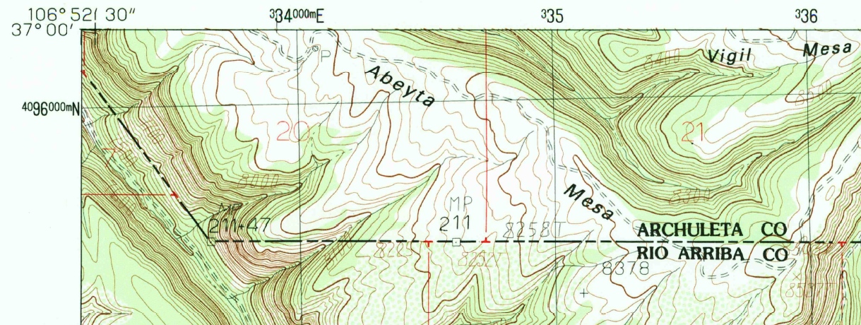
In the most famous example along Colorado’s boundary, the Four Corners area was marked about 1,800 feet east of where it should have been placed. However, under U.S. law, once the parties (in this case the states and territories) agreed on the marker’s placement it became the actual boundary. This also holds true for all of the numerous zigs and zags that make up our border. And while state maps still show the boundary as straight, any detailed topographic map (we have almost all of them in the Western History and Genealogy Department) offers a glimpse into the lives of those surveyors from the late 19th century as they laid out our modern boundaries.
Further Reading:
Geological Survey (U.S.). 1:24,000-scale topographic map of Monero, NM-CO (1983). Image at the top of this post taken from this map. USGS's Topo Viewer is the best place to find historic USGS topographic maps online.
Van Zandt, F.K. Boundaries of the United States and the several States. Professional Paper 909 (1976). Good summary of all the state boundaries.
Everett, Derek R. Creating the American West: boundaries and borderlands (2014). Up-to-date take on the western borders of the U.S.
Statutes at Large, 36th Congress, 2nd Session (page 172). 12 Stat. L. p.172 (ch.59). February 28, 1861. Established boundary of Colorado as being between 37th and 41st parallel (latitude) and 25th and 32nd meridian (longitude, west from Washington DC)
Comments
Hi Rafael, and thank you for
Hi Rafael, and thank you for your comment! When the number of sides gets that high, it's possible we'll never know the exact number, but it's a lot! Because the enabling acts creating both Wyoming and Colorado were based on specific longitude and latitude lines, the northern boundaries of BOTH states are actually shorter than their southern boundaries, since northern lines of longitude slowly merge as you get closer to the geographic North Pole. It was easy to draw the territorial boundaries in Washington, DC -- not as easy for the surveyors on the ground trying to follow those lines while running into all the canyons and mountains.
Umm. Gonna have to burst…
Umm. Gonna have to burst your logic and square.
Of course, in the northern hemisphere the northern border will always be shorter than the southern when you have parallel western and eastern boundaries. That said, Wyoming has the same issues.
Does the southern boundary
Does the southern boundary pass through Raton Pass by coincidence or was that planned?
Quite the coincidence! The
Quite the coincidence! The 37th parallel is actually slightly north of the surveyed line, and the surveyed line is slightly north of the high point of pass. That said, they're all very close together. If the surveyors intentionally laid down the boundary below the 37th parallel to get it closer to the high point, they kept that subversion to themselves.
Maybe someday while the…
Maybe someday while the earth still exists, the U.S. will just realign them to the correct all boundaries that are tied to longitudes and latitudes. We're still adjusting other boundaries. Any short and medium-term hassles could possibly be offset with reduced costs over the long-run from surveys, taxes, etc.
Add new comment