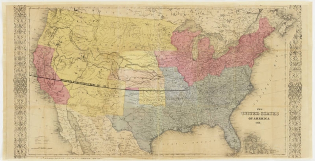
Denver Public Library's Western History and Genealogy Department owns many rare maps. Rarer still is the opportunity to acquire what may be the only surviving copy of a map from a foundational period of Colorado history. Recently we acquired this excellent and likely unique example of a map created on the frontier by taking a map published by someone else and re-packaging it for a new purpose: selling to prospectors.
Imagine Kansas in the late 1850s, when rumors about gold finds to the west were flying about. Enterprising businesses were scrambling to meet the demands of the never-ending stream of would-be millionaires. This gold rush map, and the enterprising business that produced it, offered the prospector everything they needed: supplies for the trip, directions to get there, and the convenience of one-stop shopping. Though perhaps now lost to history, we believe at one point, a printed shopping list had been attached to the map, since residual type can be read near the label for the Atlantic Ocean, listing such necessities like salt, bacon, and coffee. Also, if you look closely at the space between Kansas City and Pikes Peak, you can make out several hand-drawn routes suggesting travelers follow rivers and already established trails.
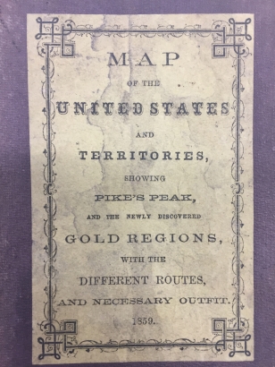
While the shopping list might be lost, our unidentified entrepreneur was careful to package the map in a handy cover with its own title, adding to the product's uniqueness.
Whether this only known copy of the map was purchased by someone who (presumably) made it alive to Colorado, or whether it found its way, unsold, into a storehouse where it sat unused, we do not know. But we do know it adds to our understanding of the heady days of the Pikes Peak Gold Rush.
Many thanks to Wes Brown and the Council for Western History and Genealogy, as well as Barry Lawrence Ruderman Antique Maps, for helping to make the purchase of this map possible.
Browse our Digital Collections to explore this and other maps in our collection.
The map itself was produced by taking a map published by someone else (who in turn had taken someone else's map -- copyright meant little on the frontier) and re-packaged it for yet another purpose: selling to prospectors. If you look closely at the space between Kansas City and Pikes Peak, you can make out several hand-drawn routes suggesting travelers follow rivers and already established trails, leading to an appropriately hand-colored area of gold showing where to dig. This indicates that the seller put in at least some effort to help the buyer reach their destination alive.
Whether this only known copy of the map was purchased by someone who (presumably) made it alive to Colorado, or whether it found its way, unsold, into a storehouse where it sat unused, we do not know. But we do know it adds to our understanding of what life was like for both prospector and outfitter during the heady days of the Pikes Peak Gold Rush.
Denver Public Library's Western History and Genealogy Department owns many rare maps. Rarer still is the opportunity to acquire what may be the only surviving copy of a map from a foundational period of Colorado history. Many thanks to Wes Brown and the Council for Western History and Genealogy, as well as Barry Lawrence Ruderman Antique Maps, for helping to make the acquisition of this map possible.


Comments
This was a very good source!
This was a very good source!
Add new comment